Postcards from the South West Part 2
Share this page

I have spent the last couple of weeks touring around the whole south west coast from Bristol to Land’s End and back to Southampton. The primary goal was to spread the word about my new book on the south west part of the England Coast Path (link). As ever I have been wonderfully surprised by the support I have received from small outlets – independent book shops, gift shops, museums and information centres – who have stocked a book by someone just walking in off the street carrying a box. In fact I’ve found this approach works better than phoning ahead, emailing information and trying to set up meetings. As long as the right person is there, they open the box with fresh eyes and I love watching their joy at leafing through my books, finding their own local of the path, then being delighted at some nugget of information or choice of song for the day. But the trip has also given me time to revisit some of my favourite places at a time of year when spring is trying to blossom fully and the south west, while still blissfully quiet, is just starting to feel like paradise. Here are some postcards from these places along the south coast of Cornwall, Devon and Dorset.
Lands End
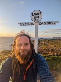
While waiting for the manager in the cold visitor centre that forms part of the monstrous theme park at Land’s End, I suddenly fear that I have been disparaging about it in the book I am trying to sell them. I skip to the relevant pages and discovered with relief that I had restrained myself from condemning it, perhaps with this possibility in mind. I am informed that the place is owned by someone from up country, who comes down twice a year to boss people around – it does seem a great shame that if someone is going to own as significant a piece of land as this and benefit from it that it isn’t at least a local figure, even if not the council or local community. It is relatively quiet today, but there is still a busy trade, hundreds paying for parking, photos with the iconic sign, tat from the shop and pirate, Aardman and farm tours. I do not sell any books here today, but then most of the books in the shop are so insubstantial as to barely warrant the name, so different from all the small places I have been selling.
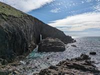
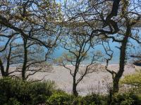
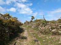
The only benefit of hanging around for half an hour is that they’ve had to sign me into the car park, so I can now stay all day. I set off for a run along the spectacular coast that surrounds Land’s End and breathe easier when bounding over the granite towers that plunge so definitively into the Atlantic Ocean. Ancient orthostatic walls are the only other feature on this elemental section of coast, but it seems a lot more benign on a bright sunny day than it did on my last visit, when grey cloud lent it an other-worldly air. At Porthgwarra I explore the fascinating tunnels dug through the cliffs not by smugglers but farmers who gathered seaweed from one of the few beaches here to fertilise their fields. The hamlet’s old paths are green and lined with ancient walls, leading me inland to cross the fields back to Mill Bay, better called by its Cornish name of Nanjizal. A beautiful cove far from the roads, it is home to the Song of the Sea Cave, a slit in the headland that you are said to be able to swim through. Today though, the waves are still high and surge powerfully through the channel, and I am informed by a naked couple on the rocks that the tide is too low to swim into the cave anyway. I swim on the beach instead, picking my way through the seaweed to be blasted by the waves for a few minutes. The sea is already warmer than last week. Sumer is icumen in.
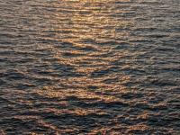
I stay late into the evening to watch the sun set off Land’s End. At this time of night you can walk down to the signpost and take your own photo for free, then step over the ropes that protect the cliff edge and clamber down through the rocks. Just below the hotel there is a curious shelter carved in the rock, then a little further down a balanced boulder forms a natural cromlech. I duck through the arch and stand on a ledge overlooking the ocean. The sun dips towards the horizon beyond the Longships Lighthouse and the sea below crashes hard against the last rocks in England. The sea in between is a flurry of waves and white horses, but in the light of the sinking sun it starts to glint gold on each crest. The gold pattern takes over the whole arc between me and the sun, shimmering in each instant so the pattern changes constantly like a fabulous gold veil. This magical vision only fades as the sun slips over the horizon and the sea is suddenly sullen and dark, the truth of its nature. I think of the schoolchildren who were washed from those rocks at my feet in 1985 and shiver in the western wind.
The Helford River
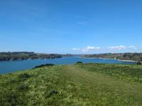
Just a few miles outside Falmouth, the Helford River is a wonderful ecosystem of its own. On a blazing hot April Sunday, I join the line of traffic on the lanes out past Mawnan Smith to the accessible side of the estuary (the Meneage side is truly remote and rarely busy). Parking in Mawnan, I bound along the crest of the slope leading down to Toll Point, which offers sensational views across the estuary and a real sense of freedom (no ‘Stick to the Coast Path’ signs here). I pass Porthallack and Porth Saxon, where I had swum off the idyllic flat pebbles on my last visit, that time during the heatwave of 2021. Today’s heat is more bearable, but the tide is out and the shore more rocky and weed-covered, so I continue up through the lush exotic woods around Bosloe. On my way down to Grebe Beach, I pass the legendary Cornish band 3 Daft Monkeys and have a lovely chat – this is exactly how I hoped they spent their time. The beach is pretty busy, but the turquoise waters of the Helford are idyllic and I am quickly lost in its cool embrace. Opening onto the sea to the east, the estuary is invariably sheltered and wave-free, with views half a mile across the water to the other shore, so it doesn’t quite feel like the sea. I lie peacefully on my back, soaking up the sun’s rays until I am too cold to continue the illusion of being in the Med, then yomp swiftly back up through the pines to warm myself up again.
Blackpool China Clay Works
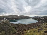
Parking up on a quiet lane on the hills above St Austell, I notice a path signed off to St Mewan Beacon, so take a short walk up across the heath of Burngallow Common to the heap of granite rocks that I assume to be the beacon. There are great views across the town towards the arc of St Austell Bay and across the china clay works nearby, but the path appears to continue. It soon leads across a broken down fence on the end of the vast Blackpool China Clay Works and I enter tentatively, if only to take a closer look at the curious circular tanks on the hill above. They are revealed to be x, full of water and great stirrers, but their most striking features are the tabs of corrugated iron that surround them. A track leads on up the hill, then cuts through a narrow ravine of china clay spoil to emerge overlooking a mile-long lagoon amid the workings. Its cobalt blue colour looks at once appealing for a swim and yet slightly unnerving, while beyond it towers the great heap of Watch Hill, a natural hill made to look artificial by the workings set into it and the white hue of its scarps. A little further on I look down on a series of conical white slag heaps, smaller version of Scredda Mountain’s archetypal Cornish Alp, which dominates the St Austell skyline. It is a fascinating area to explore, so at odds with the natural wonders down on the coast, and one which the nearby Eden Project has made great use of, only here the journey doesn’t cost £42 per head.

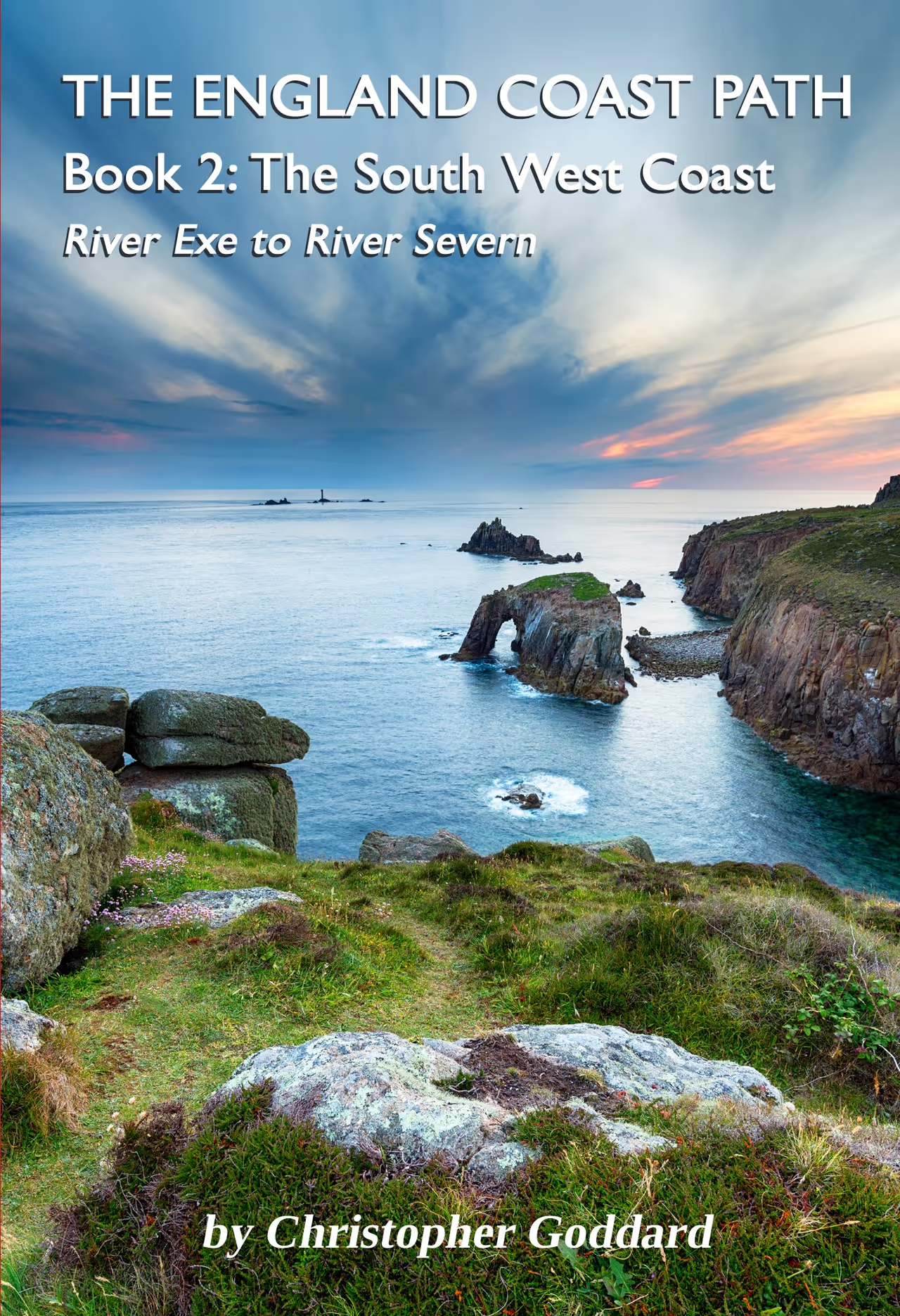
The England Coast Path - Book 2: The South West Coast
£15.99A practical guidebook for walking over 650 miles of the England Coast Path from the River Exe to the River Severn. Starting in Exmouth and finishing in Chepstow, this book covers the coasts of Devon, Cornwall, Somerset & Avon.
Buy NowBodmin Moor
Looking at Bodmin Moor on the OS map, it looks remarkably spartan and uninteresting. It is also exceptionally hard to plan a walk or run as there are so few paths and an awkward patchwork of Open Access land. I wonder if I shouldn’t bother – it happens to me every time!
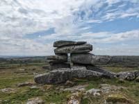
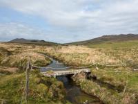
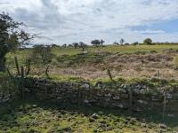
Anyway I do persist, leaving the coast to explore some interesting names on the map. First up is Trippet Stones, a stone circle that would probably be the finest in West Yorkshire, but here the six-foot high granite stones lie unheralded on a lonely shoulder of moor. A mile further on, a short detour leads up to King Arthur’s Stone, marked only as Cheese Wring on the map. It is an impressive heap of stacked granite rocks with a hole through the middle (a reference to the Sword in the Stone perhaps) near the chimney and ruins of quarry workings, as well a series of small deep pools on the edge of Carbilly Tor. The only reason I don’t run through these sites is there appears to be no way to link them with the main more without trespassing. So, after negotiating the sheep, horses and long-horned cattle that roam the roads, I park up a mile further on at Delford Bridge.
A public footpath leads promisingly across the fields, the sort of ancient landscape divided by huge Cornish hedges that characterises the edge of Bodmin Moor. The stiles are huge granite ladders over the two-metre high hedges and the path soon joins an old road leading away from Bradford. High meandering walls hem the route and gorse starts to clog the way, until I am picking my way gingerly through it. Then the right of way just stops (I hadn’t noticed this on the map), so I have to roam through fields and vault gates to link up with the next path leading off the common of Emblance Downs. Except this path just doesn’t exist and after climbing one wall, I’m left to jump down another and brave the soggy hollow around a stream. It turns out to be wet, but not likely to swallow me as some bogs round here, leaving me only to wonder how you’re supposed to explore this area legally.
The only person I see is walking dogs just off the road near a hut circle on the edge of the moor – nearby are several standing stones that seem far more intriguing, everything looking like a prehistoric site in this context. Once on the open moor, the running is very easy as the grass is cropped so short by livestock, so the lack of paths becomes I irrelevant, but I do follow one through a conifer plantation and round the hillside to Garrow, a private-looking bothy in the remote heart of Bodmin Moor. The twin peaks of Rough Tor and Brown Willy loom on either side of the head of the De Lank River and for a moment I am tempted to make a bolt for the latter, Cornwall’s highest point. If there was a path I may have, but it was still hard to pick a route through the myriad fields and rocks from here, so I double back up the slopes of Garrow Tor, a fine collection of weathered granite outcrops with great views. Part of Bodmin Moor’s appeal lies in its inaccessibility and inhospitality – I respect that it refuses to yield its treasures easily.
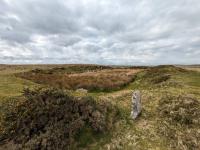
The path I pick up off Garrow Tor leads to an enclosure on the edge of the moor, hence another trespass across fields to reach King Arthur’s Downs. This blissfully shorn expanse leads up to another feature I’d been intrigued by on the map, King Arthur’s Hall. On approach it is a large embankment surrounded by a fence, but after ducking through the sheep creep in its perimeter, I behold a huge stone-lined space around 20m by 50m with a boggy pool at its centre. It’s easy to see why the name arose as it’s a truly curious prehistoric site, the like of which I have never seen before. It is thought to be a Neolithic ceremonial site, but it’s true purpose remains enigmatic, like many of the moor’s secrets.
Prawle Point
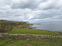
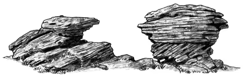
East Prawle, Devon’s most southerly village, is not an easy place to get to, accessed by miles of single track sunken lanes. As a result it is a very tranquil place, with little activity around its small green. With both the Pig’s Nose Inn and Piglet Cafe close, I set about cleaning the van as it has become caked in rich brown grime from the lanes of the south west and the tornado that swept through last week. I then continue along the road, a byway that is barely wide enough for the van to reach the Prawle Point car park at the end of the land. Galloping down the grassy slope, one of the most fascinating sections of coastline in Devon opens up. Between Prawle Point and Start Point there are a series of gnarled rocky outcrops above the greensward along which the coast path runs – these schist formations with names like Lobeater Rock and Fish-in-the-Well Rock represent former headlands when sea levels were higher during the last inter-glacial period 100,000 years ago.
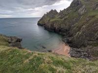
A series of bunkers formed part of the World War II defences along this remote shoreline, including the lookout of Prawle Point. It is a blowy day, with gusts of wind racing across the surface of the water as I follow the shore round to Signalhouse Point, where ancient orthostatic walls blend with the rugged natural rock formations. It is a dramatic section of the coast path, leading to one of its most secluded bays, Maceley’s Cove. A narrow strip of bright sand sheltered beneath the pinnacles of Gammon Head, it calls to me even on a cloudy evening. Last time I was here, yachts from Salcombe thronged the bay and people frolicked in the water like they were in the Greek islands. Today, as I pick my way steeply down to the cove, I have it entirely to myself and am soon running headlong into the cold water. It is an idyllic spot for a swim, but the wind makes it hard to lie back and relax in the water. I stay as long as I can and trace my footprints in the sand, the only ones on the beach since the last tide. Then, as I climb back up the cliffs, a motorboat speeds around the corner from Salcombe and into the bay, filling it with noise – I am relieved I had my few moments alone.
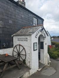
Back at the Pig’s Nose, I enjoy Devon beer from the wood. Flat and lifeless, it would offend my northern drinking allies, but I love tasting it when down this way. The pub is a unique place, with historical links to smuggling as well as a period as a petrol station. It is quiet tonight, but it has hosted a plethora of impressive gigs, including by the likes of Dr Feelgood, Atomic Kitten, The Animals, The Bhundu Boys and The Good, The Bad and The Queen (whose song Start Point (Sketches of Devon) was my pick as the song for this day’s walking in my book). However, as the name suggests, it is no place for a vegan. The pub is named after one of several features on the nearby coastline related to pork products – as well as Pig’s Nose and Gammon Head, there is Bacon Hole and Ham Stone.
Soundtrack
Siouxsie and the Banshees – Land's End
The England Coast Path - Book 1: The South Coast
£15.99A practical guidebook for walking over 700 miles of the England Coast Path from the River Thames to the River Exe. Starting in Woolwich and finishing in Exmouth, this book covers the coasts of Kent, Sussex, Hampshire, the Isle of Wight and Dorset.
The England Coast Path - Book 2: The South West Coast
£15.99A practical guidebook for walking over 650 miles of the England Coast Path from the River Exe to the River Severn. Starting in Exmouth and finishing in Chepstow, this book covers the coasts of Devon, Cornwall, Somerset & Avon.
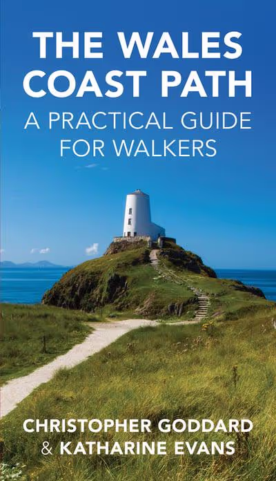
The Wales Coast Path
£15.99A detailed colour guide to the full 890-mile long distance trail of the Wales Coast Path from Chester to Chepstow. 2nd edition published December 2020.