Book Updates
It has occurred to me that, after nearly 10 years of my books being out in the world, that I need somewhere to highlight corrections and amendments to some of my older material. Things change fast and I have become aware of a few routes that now have obstructions on them that make them hard to follow, particularly in The West Yorkshire Woods: Part I, where previously accessible but informal paths have been blocked off with no course legal recompense. All reprints of my books are continually updated but I appreciate that this is not enough to make you go out and buy a new copy, so from now on I will collate all significant route changes here to hopefully avoid as many people coming unawares upon a series of barbed wire fences.
The Sowerby Bridge Industrial Heritage Walk 1
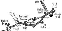
The route between Hob Lane and Goose Nest Lane is reportedly blocked by rubbish past Prospect Terrace. It is simple to avoid this though by continuing up Hob Lane past the Hobbit, then turning right onto Goose Nest Lane.
The Sowerby Bridge Industrial Heritage Walk 2
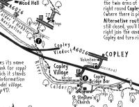
The route under the viaduct at Copley has been temporarily blocked to allow the embankment beyond to be reseeded. There is a simple diversion left past the cricket pitch to join the road where it ducks under the railway.
The West Yorkshire Moors (1st Edition)
Route 14: Ogden Kirk, Nab Hill & Warley Moor from Causeway Foot
The path along Warley Moor Reservoir has recently been blocked by a new fence and locked gates, even though this is designated as open access land. There is no obvious alternative here, other than hopping the gate or struggling along the edge of the very rough moor to the right of the fenceline. If in doubt, leave this route until this has been resolved.
Route 25: Withins Height, Crow Hill and Ponden Kirk from Ponden
This route is still perfectly accessible but has become much harder going with the virtual disappearance of the faint path up the side of Walshaw Dean, so much so that I removed it from the second edition. Just be aware you are in for some rough heather, bracken and tussock bashing.
Route 28: Earl Crag & Hitching Stone from Sutton-in-Craven
The route up Sutton Clough is impassable after the first bridge was destroyed in December 2023. Until that is repaired or replaced, you'll have to stay on the main road instead of heading along Hall Drive. Continue past the Bay Horse and up the hill for 1/3 mile, before bearing first right to Wood Vale Farm. Continue on a path that leads back down to Sutton Clough to rejoin the route at the clapper bridge.
The West Yorkshire Moors (2nd Edition)
Route 4: Earl Crag & Hitching Stone from Sutton-in-Craven
The route up Sutton Clough is impassable after the first bridge was destroyed in December 2023. Until that is repaired or replaced, you'll have to stay on the main road instead of heading along Hall Drive. Continue past the Bay Horse and up the hill for 1/3 mile, before bearing first right to Wood Vale Farm. Continue on a path that leads back down to Sutton Clough to rejoin the route at the clapper bridge.
Route 12: Ogden Kirk, Nab Hill & Warley Moor from Causeway Foot
The path along Warley Moor Reservoir has recently been blocked by a new fence and locked gates, even though this is designated as open access land. There is no obvious alternative here, other than hopping the gate or struggling along the edge of the very rough moor to the right of the fenceline. If in doubt, leave this route until this has been resolved.
West Yorkshire Woods: Part 1 (1st Edition)
Route 1: Judy & Shelf Woods from Shelf
Between Coley Hall and Sun Wood a number of new fences make the path across the fields less obvious and more intricate. See map below for amended point 7.

Route 3: Beacon Hill, Shibden Park, Sunny Vale and Chelsea Valley from Halifax
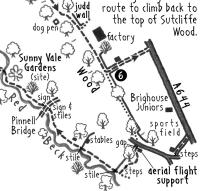
The now-private path along the top of Sutcliffe Wood from point 6 has been blocked by barbed wire at the bottom end and there is a dispute over this claimed Right of Way. In the meantime it is necessary to follow the path left beyond the factory to reach the A644. Turn right along the road for 400m, then turn right on an unsigned path beyond the Brighouse Juniors sports field. Keep right on the lane to rejoin the route by the aerial flight support, the whole diversion being less than half a mile.
Route 4: Elland Park, Cromwell and Strangstry Woods from Elland or Brighouse
Soon after point 3, the faint path along the top of Binns Wood has been blocked off. Instead you can follow Binns Top Lane all the down the hill. Double back left at the bottom to eventually join a vehicle track past Near Binns, then bear left shortly before the road and follow a path along the bottom of private Binns Wood. This climbs steadily at the far end to reach Boggart House, back on the route described in the book.

Route 5: North Dean Wood, Wainhouse Tower and Wood House Scar from West Vale or Copley
The canal bridge at point 7 has now reopened but, at point 8, the path through the churchyard of St Stephen’s Church has been blocked off at the far end, so you need to go left through a gap just beyond the churchyard and keep left around it to rejoin the riverside.
Route 6: Hebble Brook & Mixenden from Halifax
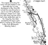
From Point 6, the original route along the lovely riverside meadows is now impassable due to a new development at Box Trees Mill. Instead the only alternative is now to turn left up Mixenden Road past Jumples Court, then turn right along Crag Lane. After half a mile, double back right to the Flying Pig, then head immediately left down a path before it emerge by the entrance to Box Trees Mill beneath Wheatley Viaduct.
Route 7: Blackburn Valley from Barkisland
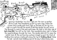
After point 3 the path on the south side of the Black Brook beyond Gate Head has been blocked off, meaning you now need to stay on the left bank of the stream throughout.
Also, between points 4 and 5 the path beyond the golf course is now legally blocked by barbed wire. Turn right here to descend out of the wood and reach the back of Gate Head Mill. Follow the track left (with a brief signed detour into the trees) to head back up the hill to rejoin the route past Stubbing.
West Yorkshire Woods: Part 1 (2nd Edition)
Route 6: Hebble Brook & Mixenden from Halifax
From Point 6, the original route along the lovely riverside meadows is now impassable due to a new development at Box Trees Mill. Instead the only alternative is now to turn left up Mixenden Road past Jumples Court, then turn right along Crag Lane. After half a mile, double back right to the Flying Pig, then head immediately left down a path before it emerge by the entrance to Box Trees Mill beneath Wheatley Viaduct.
West Yorkshire Woods: Part 2
Route 4: Middleton Park and Ardsley Fall from Middleton
Between points 4 & 5, I have received reports that walkers on the footpath through the rubble yard and beneath the M62 are on occasion being turned back by the landowner. This is a public right of way and the route does continue to Ardsley. However, there are also aggressive dogs on chains through this part of the route and my only advice at the moment is to avoid this and instead follow the alternative route, which unfortunately misses out the East Ardsley and Thorpe on the Hill section of this route.
Route 17: Bradford Beck, Bolton Woods & Wrose Hill from Bradford
Between points 5 & 6, the informal path across the field beside Carcase End Farm has now been blocked off, so you have to head left back along High Busy Lane to a gate on the right just before Laverack Hall that leads down the far side of the same field to continue the route.

South Yorkshire Moors (1st Edition)
Route 1: Three Trigs from Dunford Bridge
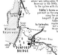
At the very end of the walk, between points 7 & 1, the informal paths leading down the dam wall into Dunford Bridge have both been blocked off by Yorkshire Water (though it is still possible to follow the rough path down through the trees from the north end of the dam wall, then follow a track left before the bridge to reach the road). Alternatively you can continue across the dam wall and follow the track all the way to the road, leading left down into the village, or turn left before the dam wall and follow a pleasant path along the crest of Broad Hill Bank, before doubling back right down the road into the village.
Route 14: Offerton, Abney & Eyam Moors from Hathersage
At the start of the walk, the path between Jaggers Lane and the A6187 is closed until September 2023 to allow a new bridge to be built over the railway. You can either follow a diversion down a path closer to the youth hostel, or use the alternative route suggested in my book, which has the added benefit of avoiding the stepping stones over the River Derwent and potential wet feet.
